![]()
![]()
![]()
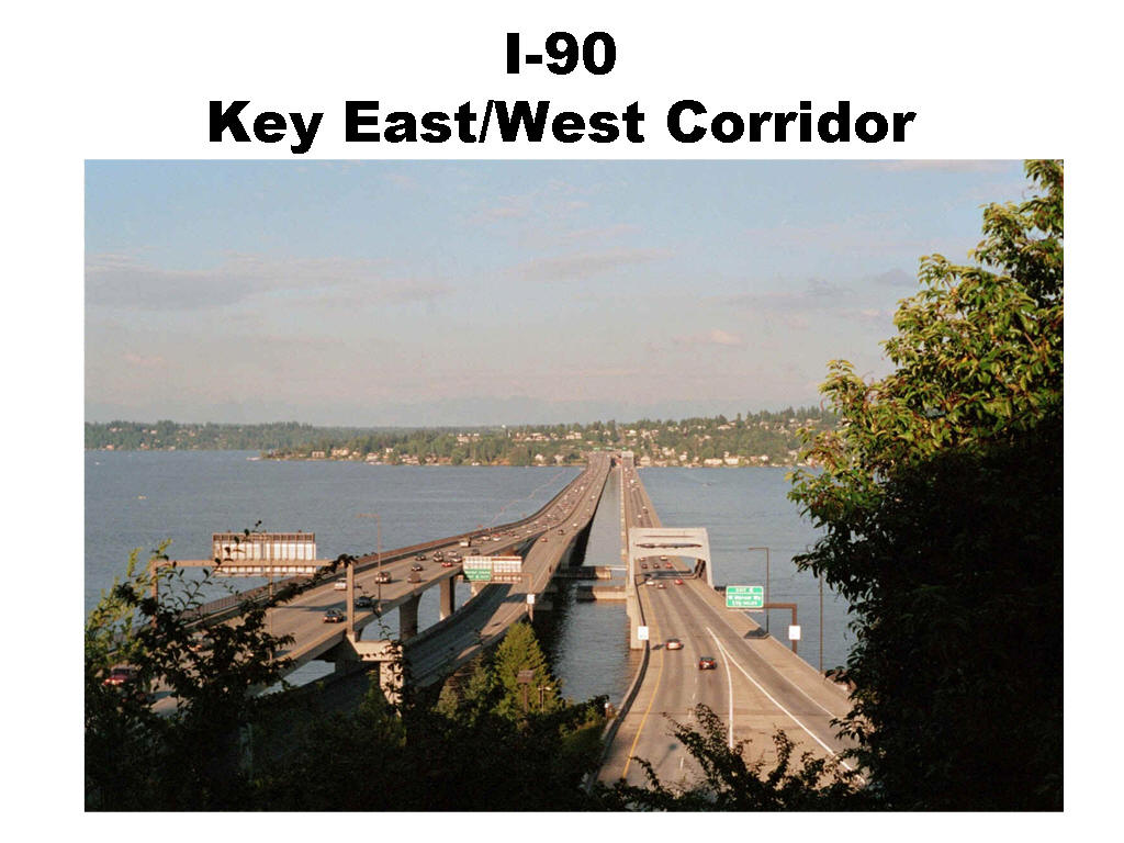
Interstate 90 across Lake Washington between Mercer Island and Seattle is a key east/west corridor for the movement of people and freight. The picture below on this page is taken from the Seattle side looking westward toward Mercer Island.
The I-90 bridge is owned by State of Washington. Sound Transit
has taken
over the center lanes of this bridge with its passenger railroad scheme approved by State Government
and the U.S..
Federal Government. This segment of I-90 is part of The
Dwight D. Eisenhower National System of Interstate and Defense Highways.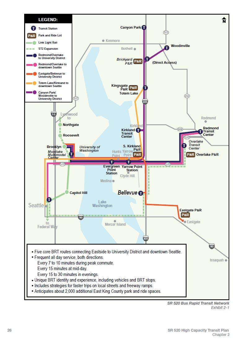
The Sound Transit Environmental Impact Statement notes that the expected 2030 ridership on East Link will be 50,000 per day, but at the same time this includes at best a net addition of 10,000 new customers to regional transit volumes. This surprisingly low increment may be the result of government plans to establish a new express bus network well before light rail completion. This network would travel on a new tolled SR 520 floating bridge with HOV lanes across Lake Washington a few miles north of the I-90 crossing, as shown at right. Click to enlarge.
Federal Highway Administration (FHWA) in November 2011 issued a Record of Decision (ROD) for East Link Light Rail to be built in the I-90 corridor between Seattle and Bellevue, a decision based upon the Final Environmental Impact Statement for East Link prepared by Sound Transit. This ROD is posted here.
The ROD lists additional approvals from FHWA that were required before Sound Transit can convert the Center Roadway of I-90 to light rail. These approvals are based on an ongoing review of negotiated agreements between Sound Transit and Washington State DOT. Approval of conversion of highway lanes to high capacity transit was required before construction can begin on the I-90 bridge.
Federal Highway Administration approvals required for East Link include:
* Interchange Justification Report, which contains the analysis necessary for FHWA’s approval of the safety and operational impacts of a change in access to the Interstate System. (Done and approved.)
* Airspace Lease for Use of Interstate Right of Way. (Approved)
* Breaks in access, including those determined necessary during the design process as well as those requested during Construction. (Approved according to message from FHWA on February 13, 2017)
* Operations and Maintenance Agreement, related to the airspace lease. (Approved)
* Approval of conversion of highway lanes to high capacity transit. (Approved)
* Approval of bridge expansion joint design. (Approved)
![]()
The bridge expansion joint design refers to the track bridge, a mechanism that connects the floating, moving tracks on the bridge with the fixed track at each end. The track bridge is arguably the leading technical challenge in converting lanes of I-90 to light rail use. The I-90 Light Rail Track Plans show a double track bridge at each end I-90 Center Roadway bridge to manage the six kinds of movement of the floating portion -- surge, heave, sway, roll, yaw, and pitch. (1.3 megabyte pdf) These plans are extracted from an appendix to the final Interchange Justification Report from WSDOT and Sound Transit prepared for consideration by the Federal Highway Administration of U.S. DOT.
An Independent Review Team (IRT) of engineers working for the Washington State Legislature studied the requirement for a track bridge and in 2008 made recommendations on how development should proceed. This document is still relevant now that a track bridge design has been prepared and tested.
Sound Transit's early 2009 summary of IRT findings and conclusions is posted here.
The Track Bridge System & Prototype Project, Phase 1 Design Services, Track Bridge System document (1.7 meg pdf) includes a description of I-90 floating bridge movement. This document was extracted from the Sound Transit RFP for consulting services procured in late 2010.
Design and prototype testing of the track bridge occurred during 2012, with field testing in 2013 in Colorado Springs. The track bridge design and testing must be approved by FHWA before light rail is allowed on the I-90 right of way. Details of the work are here.
In July 2012, Sound Transit provided an update to the Legislature's Joint Transportation Committee. Click to view a pdf of the presentation.
In September 2012, Sound Transit provided a briefing to an engineering professional association. Click to view a pdf of the presentation.
In April 2014, Parsons Brinckerhoff, part of the design team, posted a YouTube video animated visualization of the track bridge on I-90. The final scenes in the video do not accurately portray the approved road lane configuration on the outer roadways of the bridge. New HOV lanes are missing.
Four engineers who worked on designing and testing the I-90 track bridge co-authored a technical description of it on pages 56 to 76 in the March 2014 issue of Civil Engineering magazine.
In July 2015, Sound Transit staff requested an additional $20 million dollars from the Board of Directors for an extension of uncompleted engineering design work on the I-90 cross-Lake corridor. The request is documented here in a Board Motion. A report in The Seattle Times of August 15, 2015 is here.
![]() In
January 2017, the Transportation Research Board released a technical paper
co-authored by a Sound Transit manager and five of the agency's consultants
titled
"Integration of Light Rail on the I-90 Floating Bridge Across Lake Washington."
In
January 2017, the Transportation Research Board released a technical paper
co-authored by a Sound Transit manager and five of the agency's consultants
titled
"Integration of Light Rail on the I-90 Floating Bridge Across Lake Washington."
![]()
Washington State DOT has prepared an Interchange Justification Report (IJR) dated June 22, 2011 to explain Sound Transit's logic for taking two lanes of Interstate-90 across Lake Washington for light rail tracks. The IJR is available for download here, approximately 8 megabytes. For just the FHWA findings letter, executive summary, and table of contents, click here. CETA filed a comment letter that the IJR fails to meet the requirement to analyze an all-bus TSM alternative not requiring vast changes to the I-90 right-of-way configuration. Nevertheless, the IJR is now approved.
![]()
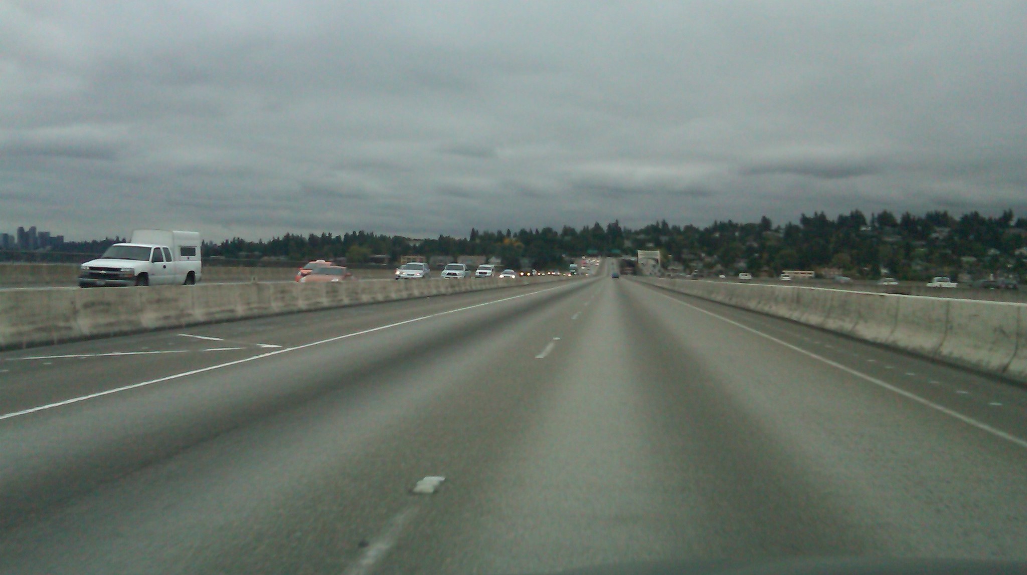
Following photos show the lanes of I-90 that light rail will take over. All the right-of-way between the concrete barriers.
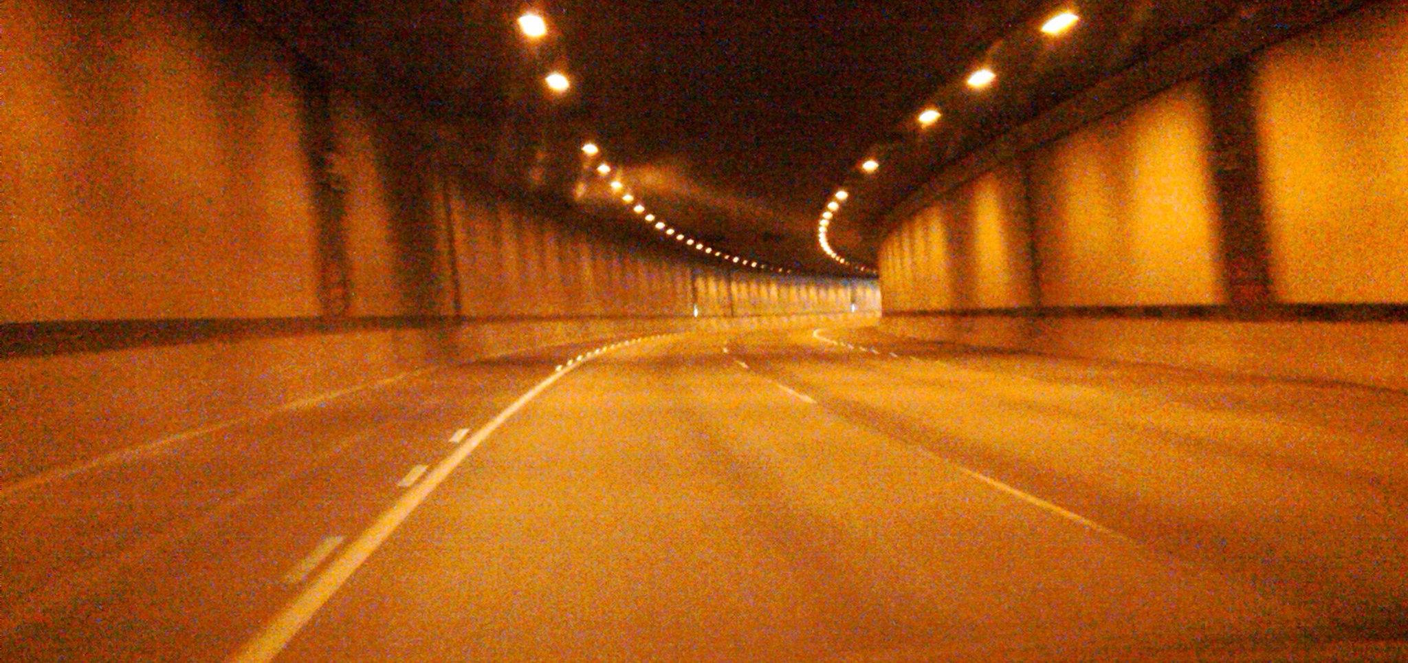
Following picture shows the reversible express lanes tunnel on Mercer Island that will be appropriated by East Link light rail.
![]()
"Sound Transit's low capacity passenger railroad scheme should be a wake up call to the region's freight community. State Government owns the I-90 bridge and should be persuaded to prevent the contemplated reduction in cross-lake freight capacity." -- John Niles, member, Puget Sound Freight Mobility Roundtable, presentation on 3-3-06.
Washington State Trucking Association in fact woke up and sent this letter in 2011 to the U.S. DOT, but light rail on I-90 was nevertheless approved by the U.S. DOT, pending the additional requirements listed above.
![]()
“Thousands of trucks from Boston to Seattle use I-90 and the floating bridge corridor every day, and we are very concerned about getting bottled up in the last seven miles.” -- Bryan Boehm of American Container Transport in Ellensburg, Washington, a trucking company that uses the I-90 floating bridge, quoted here, May 2011.
![]()
 Background: The Sound Transit Board on July 13, 2006 voted a decision to narrow its
mode preference to light rail for high capacity transit on the center roadway of the I-90 floating bridge between Seattle and Mercer Island. This would be accomplished in Sound Transit
Phase 2 following implementation of lane expansion in the outer roadway
under the R8A plan.
On the same day, Governor Christine Gregoire transmitted a letter to the Sound Transit Board of Directors advising that State Transportation Director Doug MacDonald (a Board Member) was not to vote a preference for the transit configuration on the I-90 bridge (pdf copy of this letter). The stated reason is that WSDOT was to be a co-lead agency in the preparation of documents that analyze the impacts of a "major operational change on a critical facility of the state highway system." The Governor wrote that "congestion and impact analysis already performed by WSDOT will most likely require further refinement and mitigation analysis in the National Environmental Act (NEPA) process."
The reality of the Governor's prediction in 2006 came true in the Final Environmental Impact Statement for East Link light rail, issued on July 15, 2011, and in the Interchange Justification Report mentioned above.
The center roadway of the I-90 bridge as of early 2017 is a reversible two lanes of HOV traffic flowing in the peak direction. It provides access to buses, carpools, vanpools, and (by special exception) general traffic destined for Mercer Island. The separate two lane configuration extends into tunnels on both ends of the bridge.
An approved change in the bridge configuration, R8A (with a Record of Decision), establishes four lanes in place of the existing three on the outer roadways of the bridge and in the tunnels at both ends of this bridge. This change will provide two additional HOV lanes, one eastbound and one westbound. These lanes and the ones adjacent are of substandard width for interstate highways, but approved nevertheless. According to the Eastside Transportation Association (ETA), R8A expands vehicle capacity in the AM peak by about 10%, and passenger capacity even more.
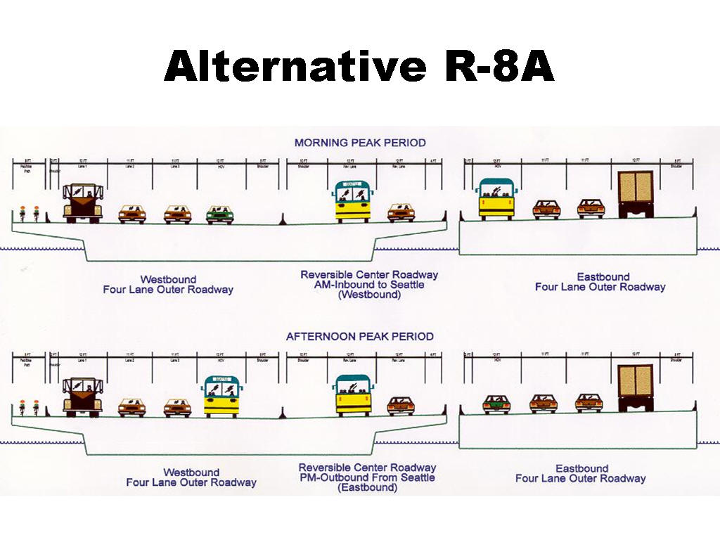
The intent of the East Link light rail program is to never allow the above road configuration to operate as shown. Instead, at the completion of R8A, the center roadway would be closed for contruction of the configuration below over the period 2017 to 2023, to be opened as shown below thereafter.
.
[Graphics above is from City of Mercer Island consistent with earlier graphics from Washington State Department of Transportation.]
Now comes a problem because of Sound Transit's intent, amplified by the interest of many political leaders on both sides of the Lake who think light rail is a necessary and good service to build between Seattle and Bellevue. The I-90 center roadway is the only feasible place to build light rail tracks across Lake Washington.
If Sound Transit succeeds in making the center roadway an exclusive transit guideway for light rail trains, the vehicle capacity of the bridge in AM peak will drop by 20% from its present capacity, and by over 30% from the R8A plan, according to analysis by the late Jim MacIsaac, P.E. of the Eastside Transportation Association, and a contributing editor at Public Interest Transportation Forum.
Quite apart from calculation based on flow modeling, converting about 26% of the bridge cross section from road space to railroad right of way is consistent with a reduction in vehicle capacity.
Sound Transit claims in the Final EIS that light rail's passenger capacity will more than compensate from lower vehicle capacity. The additional daily peak period throughput forecast for 2030 by putting light rail in the Center Roadway instead of letting it remain as an HOV facility in the R8A configuration for buses and carpools is only 3,400 according to the IJR, page PP3-2. A counterpoint not covered in the IJR is the failure of Sound Transit's forecasting abilities demonstrated by light rail ridership manifesting below forecast on the Airport to downtown line in 2010-11.
Lower vehicle capacity because of light rail should be of specific concern to all citizens interested in regional mobility, especially the freight community, for whom I-90 is the main cross-lake bridge.
![]() A related
concern is the narrowing of the shoulders in the road tunnels at both ends of
the floating bridge, required in order to fit four lanes of traffic where only
three pass now. The narrower shoulders do not meet modern fire safety
requirements and would not be permitted in a tunnel of new construction that is
used by trucks carrying flammable cargo. The before and after configuration of
the tunnels is documented in this
consulting report from HNTB. It's important to understand that the
right-hand lane of these tunnels provide passage daily for gasoline tanker
trucks. In the opinion of PITF, if hazardous cargo trucks are going to be
permitted to travel eastbound on the Seattle-Bellevue segment of I-90, the
eastbound Mt. Baker Ridge bored tube with one lane and a wide shoulder as of
2015 should be left in that configuration, rather than reconfigured for two
narrower lanes and a reduced shoulder. Alternatively, highly-flammable
loads should be banned from this segment once the tube is configured with two
lanes.
A related
concern is the narrowing of the shoulders in the road tunnels at both ends of
the floating bridge, required in order to fit four lanes of traffic where only
three pass now. The narrower shoulders do not meet modern fire safety
requirements and would not be permitted in a tunnel of new construction that is
used by trucks carrying flammable cargo. The before and after configuration of
the tunnels is documented in this
consulting report from HNTB. It's important to understand that the
right-hand lane of these tunnels provide passage daily for gasoline tanker
trucks. In the opinion of PITF, if hazardous cargo trucks are going to be
permitted to travel eastbound on the Seattle-Bellevue segment of I-90, the
eastbound Mt. Baker Ridge bored tube with one lane and a wide shoulder as of
2015 should be left in that configuration, rather than reconfigured for two
narrower lanes and a reduced shoulder. Alternatively, highly-flammable
loads should be banned from this segment once the tube is configured with two
lanes.
A better transit solution lies in establishing the center lanes as two-way HOV lanes with room for carpools and vanpools as well as buses. As shown on page two of the pdf, buses interspersed with other HOVs would maximize capacity. Buses crossing the bridge could follow a variety of routes in Eastside neighborhoods, providing better geographic coverage and superior service to a light rail mainline with stations served by feeder buses.
Another alternative is to leave the center roadway as it is, a reversible two lanes of HOV that can flow in the direction that does the most good for vehicle, people, and freight movement depending on time of day.
The HOV lanes could even be converted to HOT lanes, high occupancy toll lanes, a plan under which any available space between HOVs is monitored with cameras and computers, and allowed to be filled by toll-paying solo-driver cars and light trucks. HOVs still travel for free, and the lane is managed with the level of toll to keep it free flowing.
| Details of the planning of the I-90 transit alignment, including history, was published in two reports included in the Draft Supplemental Environmental Impact Statement for the Regional Transit Long Range Plan, available here |
| APPENDIX N: East King County Subarea High Capacity Transit (HCT) Analysis: Approach to Assessing System-Level Alternatives (1.4 megabyte PDF) Prepared by Parsons Brinckerhoff Quade & Douglas, Inc., November 30, 2004 |
| APPENDIX O: Technical Report on Future High Capacity Transit Development Along the Seattle CBD to East King County via I-90/Bellevue Corridor (2.9 megabyte PDF) Prepared by Parsons Brinckerhoff Quade & Douglas, Inc., April 2004 |
Of particular concern is this observation: If light rail tracks were to be placed in the center roadway and the trains operated as planned, there would be five miles of empty track between rush hour trains. See page 2 of the available pdf here. Drivers of cars and buses stuck in traffic on the outer roadway would look over at the tracks and see empty space most of the time. In occasional off-peak congestion, drivers would also see empty space on trains that are even farther apart than five miles.
In the better solution, a bus every 50 seconds on an HOV or HOT configuration would provide superior passenger carrying capacity, and provide space in between buses for other kinds of HOVs that would not need to use the outer roadways.
![]()
Return to the Public Interest Transportation Forum home page.
![]()
Last modified: July 15, 2017